Fire Operations Plan map user guide
How do I zoom?
![]() Click on the plus and minus buttons in the top left corner to zoom in and out or click in the map extent and then use the mouse wheel to zoom in and out.
Click on the plus and minus buttons in the top left corner to zoom in and out or click in the map extent and then use the mouse wheel to zoom in and out.
![]() Click on the home button to return to the State view.
Click on the home button to return to the State view.
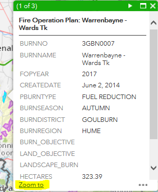
Click on the 'Zoom to' link in the pop up box for a burn:
How do I pan across the map?
To pan across the screen, use the left mouse click on the map and then drag it in any direction; or use ‘up & down’ and ‘left and right’ buttons on the keyboard.
How do I return to a previous view?
![]() Use the backward arrow to return to the previous view or the forward arrow to move to the next view.
Use the backward arrow to return to the previous view or the forward arrow to move to the next view.
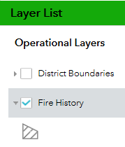
What information is available?
You can choose what layer information to show on the map and the type of image background to display it on.
![]() Click on the different layers from the Layer List.
Click on the different layers from the Layer List.
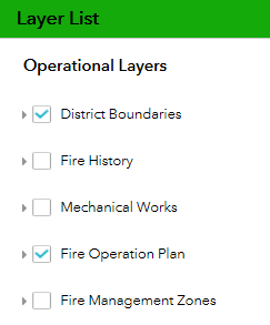
- Fire Management Zones
- DELWP District boundaries (the name of the DELWP District will appear near the centre of the map every time you zoom or pan)
- Fire history (last 5 years of burns & fires)
- Mechanical works
- Fire Operations Plan (includes all burns on the approved 3 year Fire Operations Plan)
![]() Basemap Gallery
Basemap Gallery
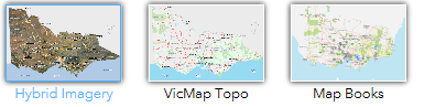
The Basemap Gallery allows the user to choose the base layer; either satellite imagery, VicMap topo base or Spatial Vision MapBooks base.
How do I search for Districts?
![]() Click on the magnifying glass and enter the name of the district.
Click on the magnifying glass and enter the name of the district.
The tool will automatically list the options once you start typing and once you select a district it will automatically zoom to that location and highlight the district.
To turn off the search, click the magnifying glass again.
How do I print a map?
![]() Click on the Print button and a basic dialog box opens where the user can give a map a title, and select the layout and the format. There are multiple layout and format options available.
Click on the Print button and a basic dialog box opens where the user can give a map a title, and select the layout and the format. There are multiple layout and format options available.
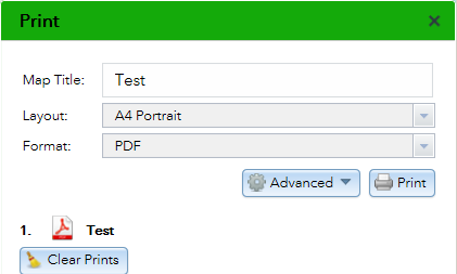
The Advanced button gives the user more control over map scale, metadata and print quality.
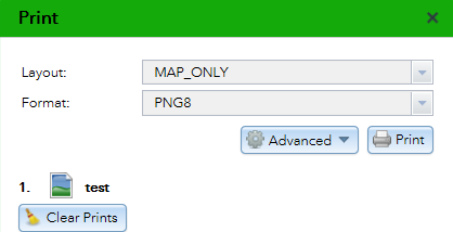
When choosing the Format MAP_ONLY, you need to give the map a title, before choosing this format, otherwise the print request fails.
Tips for viewing information
- if you can’t see a feature you have selected, try zooming in. Burn boundaries only appear when zoomed in.
- if you still can’t see the information, try panning. You may need to zoom out, pan a little & then zoom back in again.
- if there are burns near each other the burn icons may overlap - zoom in to see each burn separately.
- to hide information, click in the corresponding box in the layer list so it is not selected.
How do I see all planned burns that are going to be carried out on public land?
This map shows the size and shape of each planned burn that has been approved for the next three years. Each burn is shown by its indicative year on the FOP.
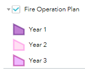
- Click on the Fire Operations Plan layer and click on the arrow to show the legend.
- zoom in to see information about individual burns – each burn shape includes the burn name, the size of the burn in hectares and the burn’s unique code number (for example 3MBD0012).
- the proposed year for the burn is also shown - note that any burn may be carried out earlier or later than stated due to changing conditions, including weather.
- if you can’t see any burns on the map, try panning to a different part of the map. Or zoom out, then pan until you have a burn in the centre of the map - then zoom in again.
How do I see Fire Management Zones?
The map can show the four types of fire management zones that apply on public land in Victoria.
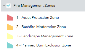
Click on the Fire Management Zones option in the Layer list to see the different Fire Management Zones.
How do I see planned burns on public land that were carried out in past years?
In the layer list select Fire History. The layer shows fire history for the last 5 years - this includes bushfires and planned burns.
- Zoom in to see burns or bushfires that have occurred in an area of interest.
- Grey outlines will appear – each grey shape represents a past fire or a past planned burn.
- Click on the fire history shape to see more information about each fire, including its name, size in hectares and date when the bushfire or planned burn occurred.
- Click Zoom to, to zoom to the historic fire shape.
To understand how risk has changed as a result of bushfires and fuel management activities, go to the Safer Together webpage and select the risk landscape of interest.
Page last updated: 04/09/19